
Every mining tenure in Queensland and Western Australia, and the changes to them, tracked nightly
One index, a state at a time. Each edition shows every tenure with its holder and parent company, what changed overnight, what's coming up, rehabilitation cost and approvals, behind one sign-in and one watchlist.
Already a subscriber? Sign in · Best on a computer or tablet
Queensland and Western Australia
Each state is its own edition, built from that state's registers. Switch between them with the state names at the top of the index. Western Australia is included in every plan at no extra cost until 31 January 2027, and founding subscribers keep it for as long as they stay subscribed.
What the WA edition adds
WA's registers show each tenement as it stands today. The WA edition adds a dated record of what changed, the rehabilitation figures that are hard to find, and the environmental approvals over the ground.
- 30,545 tenements, refreshed nightlyExploration and prospecting licences, mining, general purpose and miscellaneous leases and retention licences, each with its holder, parent company, mineral field, MINEDEX project, expiry and changes, all on one map.
- Rehabilitation liabilityThe Mining Rehabilitation Fund's rehabilitation liability estimate for about 20,000 tenements, roughly A$5.1 billion in all, with each tenement's history back to 2014. Also 210 mine closure plans with their stated costs (A$805 million) and company rehabilitation provisions.
- Environmental approvals935 EPA-referred proposals mapped against the tenements they sit on. Ministerial Statements and DWER licences and works approvals are linked to their titles, with 23,738 conditions to search.
- One watchlistFollow a company, a parent group, a tenement or an area across Queensland and WA. The morning email and the Monday brief cover both states.
The index, start to finish
A narrated walk through what changed overnight, a tenure and its drilling, a company's whole position, rehabilitation cost and the watchlist, shown on the Queensland edition. The WA edition works the same way. Sound on.
See what changed overnight, on the map
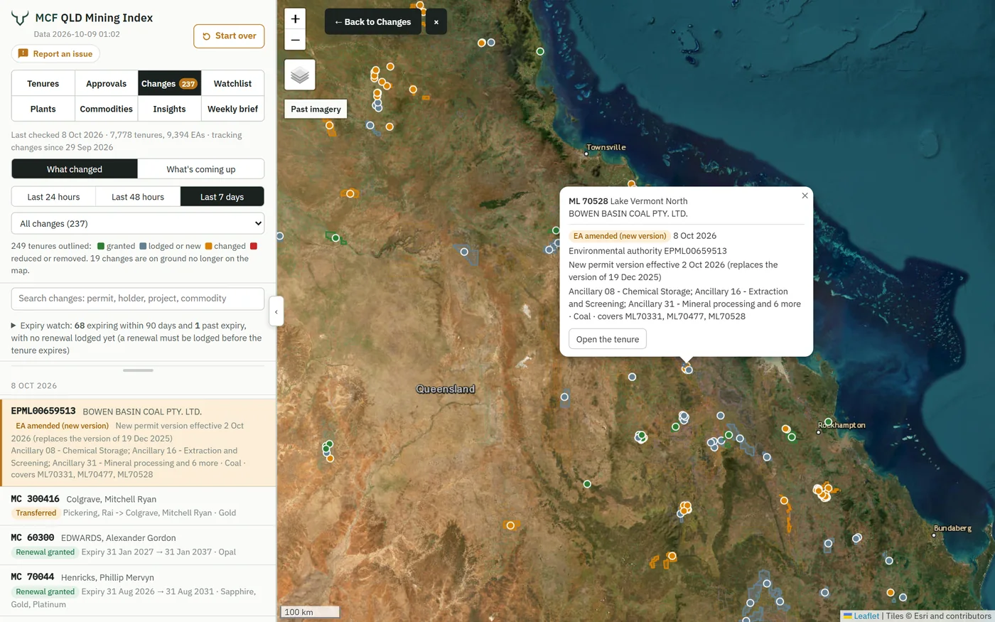
Each night the index compares each state's registers with the night before. Every application, grant, transfer, surrender and expiry is outlined on the map, and in Queensland every EA change too: click one to see what changed, then carry on through the list.
 12345
12345- The last 24 hours, 48 hours or 7 days, and the type of change
- Every change outlined on the map: granted, lodged, changed, or reduced and removed
- Click one to see what changed, then open the tenure
- Back to Changes, to carry on through the rest
- The same changes as a list, newest first, and searchable
176 changes in the week to 11 Oct 2026
Four of them, each mapped against the tenures around it, the way subscribers see them. Western Australia's changes are drawn the same way.
Melchior Minerals
13,591 ha of all minerals ground at Sujeewong, Western Downs Region.
Origin Energy Future Fuels
Reduced by 23,337 ha at Blackall, Blackall Tambo Region. Relinquishment is often required at renewal.
Auburn Resources
32,549 ha of all minerals at Lawn Hill, Burke Shire. Expires 24 Oct 2026; a renewal must be lodged before then.
Silver Star Resources
2,404 ha of all minerals ground at Silver Spur, Goondiwindi Region.
What the index records that the registers don't
Queensland's and Western Australia's registers show each tenure as it stands today. The index keeps a dated record of what changed: a permit cut back, transferred or surrendered, a tenement that reached its end date, or a Queensland EA reissued with new conditions.
- Ground as it's releasedSurrendered, expired, refused or cut back, flagged the morning after. In WA, 1,582 granted tenements ended in the last 12 months, each with its outline and the open-file drill holes inside it. In Queensland, released ground can't be applied for until a moratorium of at least two calendar months ends; new coal permits generally go to tender.
- Who's moving, and whereEvery application, grant, renewal and transfer, by company and parent group, building into a picture of who's expanding and who's pulling back, by region in Queensland and by mineral field in WA.
- What changed in a permitWhen a Queensland EA is reissued, the conditions added and removed, side by side, not a new PDF to read from scratch.
- Expiries nobody renewedGranted tenures running out with no renewal lodged: the ground most likely to come free next.
The deadlines ahead, months before they fall due
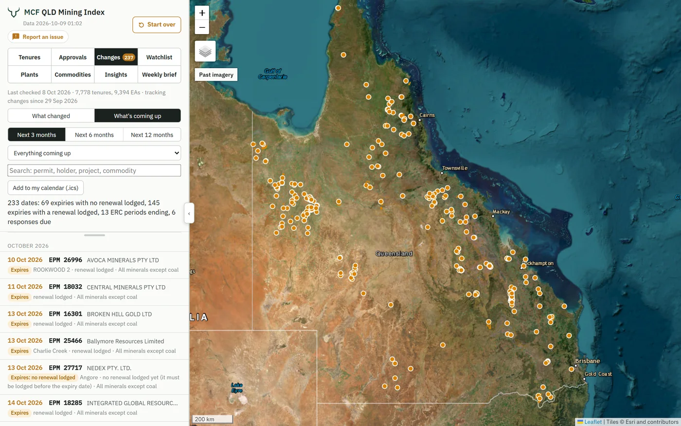
Tenure expiries and renewals run to a deadline in both states, and in Queensland so do rehabilitation cost reviews and information request responses. See every one three, six or twelve months out, by region and commodity, with its holder and project. Holders and investors see what's falling due across their ground; consultants and advisers see where clients are likely to need support, early enough to plan for it.
 12345
12345- Three, six or twelve months ahead
- Renewals not yet lodged and, in Queensland, rehabilitation cost reviews and information request responses due
- Every date into Outlook, Google or Apple Calendar
- Mapped, by region and commodity (by mineral field in WA)
- Each with its permit, holder and project
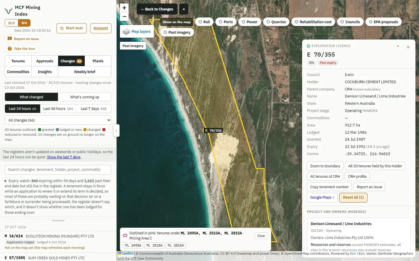
Every permit, its holder and its historic drilling, and every company's whole position, state by state
Who holds the ground next to yours, what a competitor applied for this month, which permits lapse in the next 90 days, what the drilling found, and what each company carries in rehabilitation cost, in Queensland and in Western Australia.
 1234
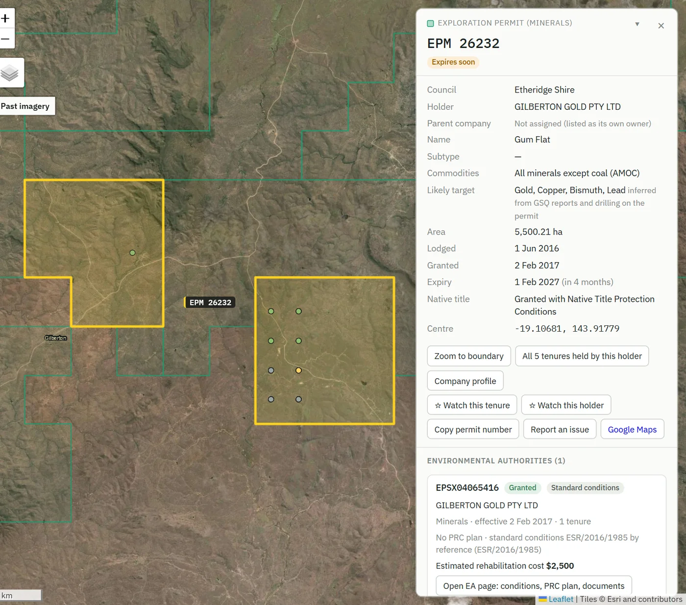
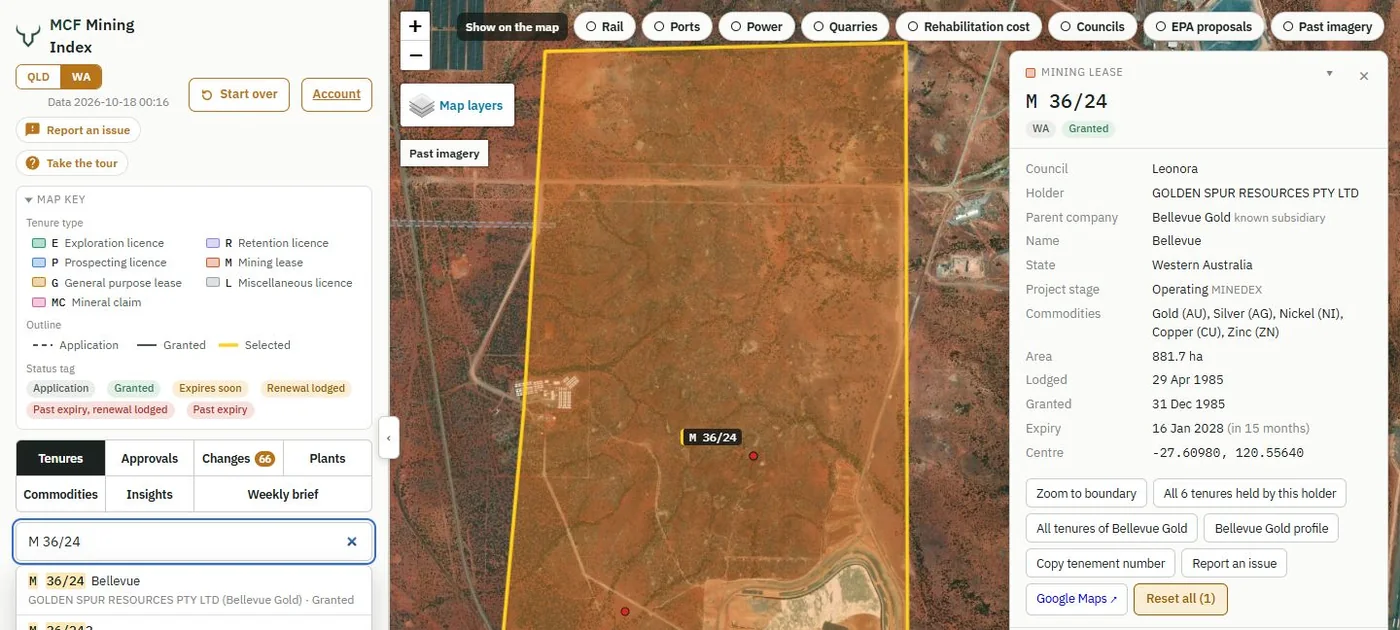
1234Every permit, with its historic open-file drilling
- Historic drill holes on the permit, coloured by year or commodity
- The likely target, inferred from the drilling and reports where the permit names none
- Watch the tenure or its holder: changes are emailed the next morning
- Its environmental authority, rehabilitation cost, conditions and documents
 1234
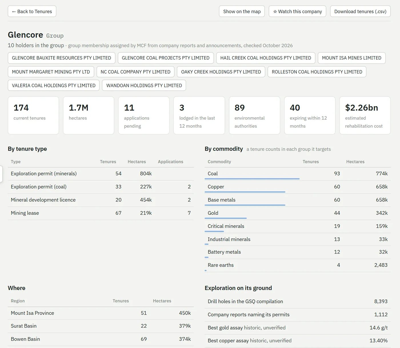
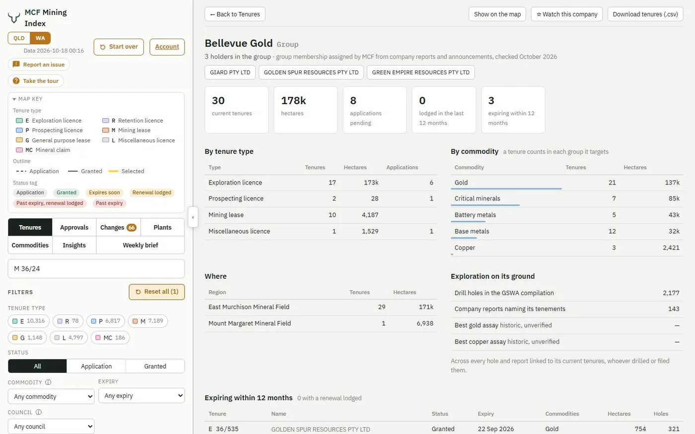
1234Any miner's whole position in a state, on one page
- Every tenure, hectare, application and EA the group holds, across all its companies
- What's expiring in the next 12 months, and whether renewals are in
- The estimated rehabilitation cost across every EA it holds
- Ground by commodity and by region, then its drilling and best assays
The ground through time, and everything around it
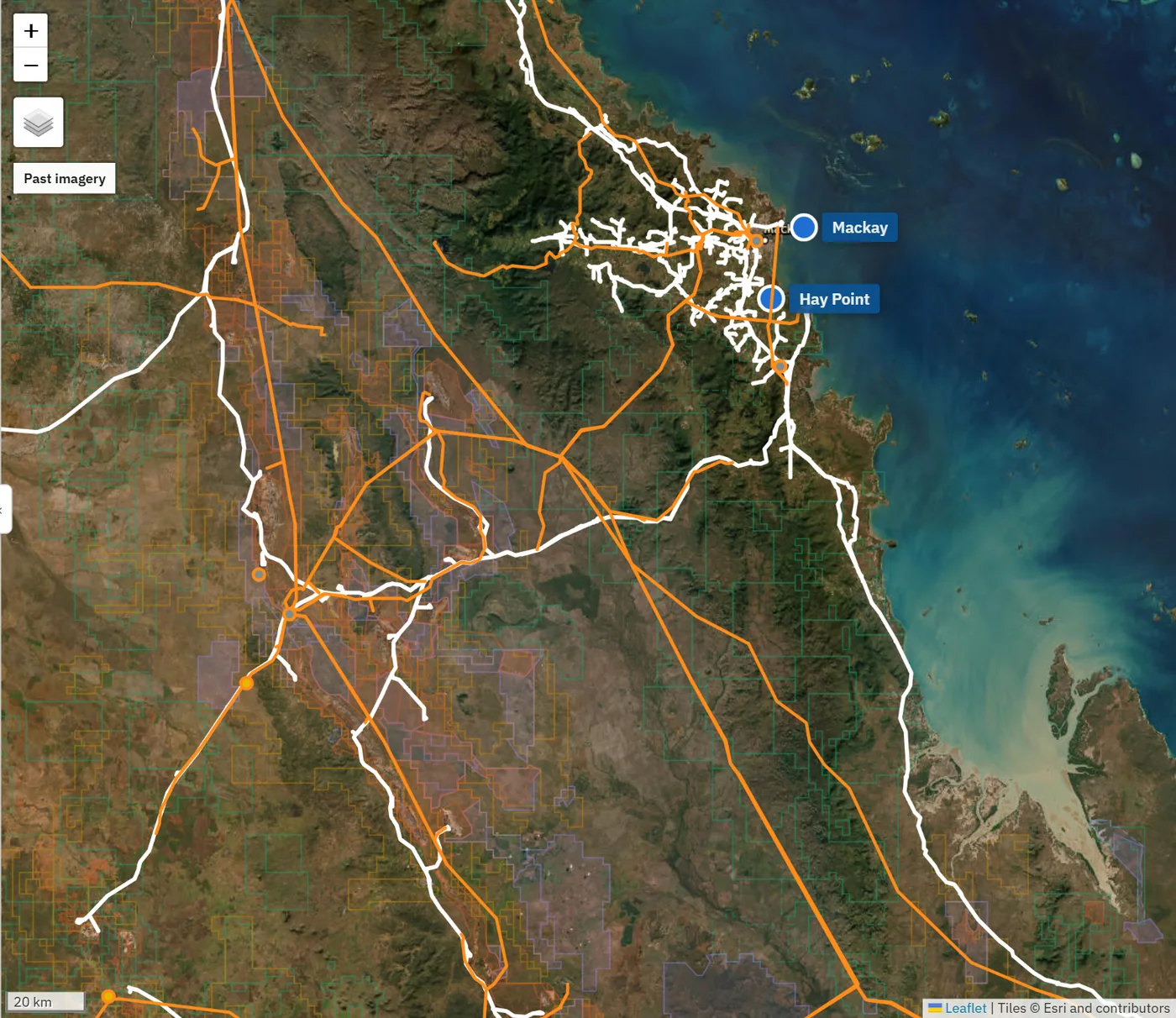
Step back through every satellite imagery release since 2014 to see when a pit opened or a site was cleared, on any tenure in either state. Switch on railways, ports, power lines and quarries to see how ground connects to market, or narrow everything to one council.
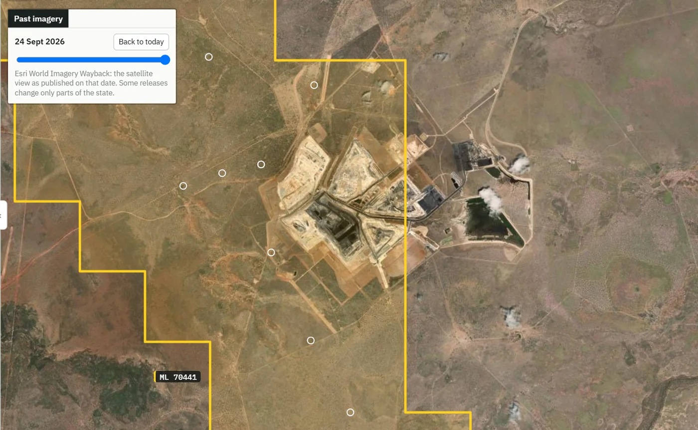
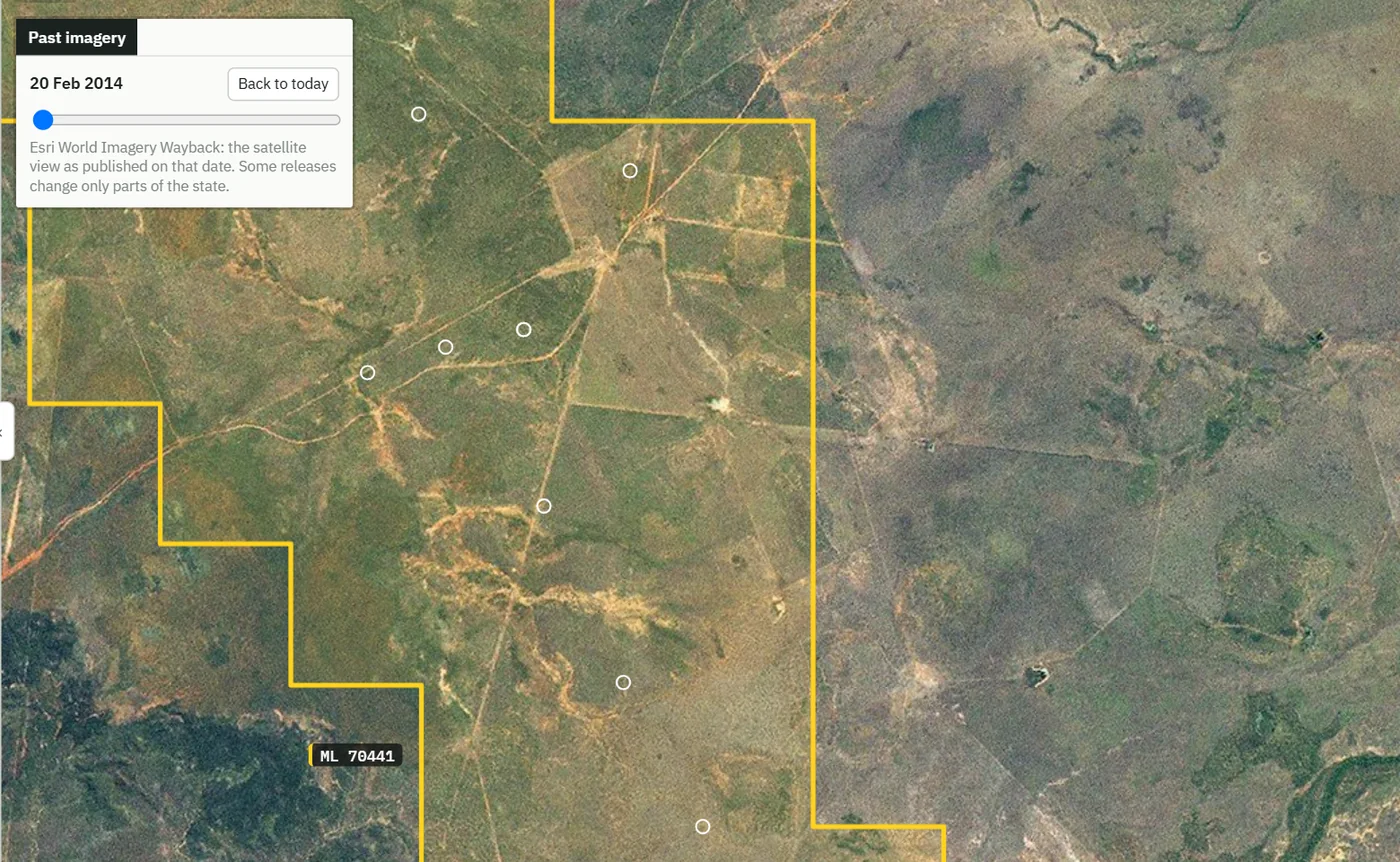
Drag across: the Carmichael coal mine in Queensland (ML 70441) in February 2014, before construction, and in September 2026. Past imagery is on every tenure in both editions.
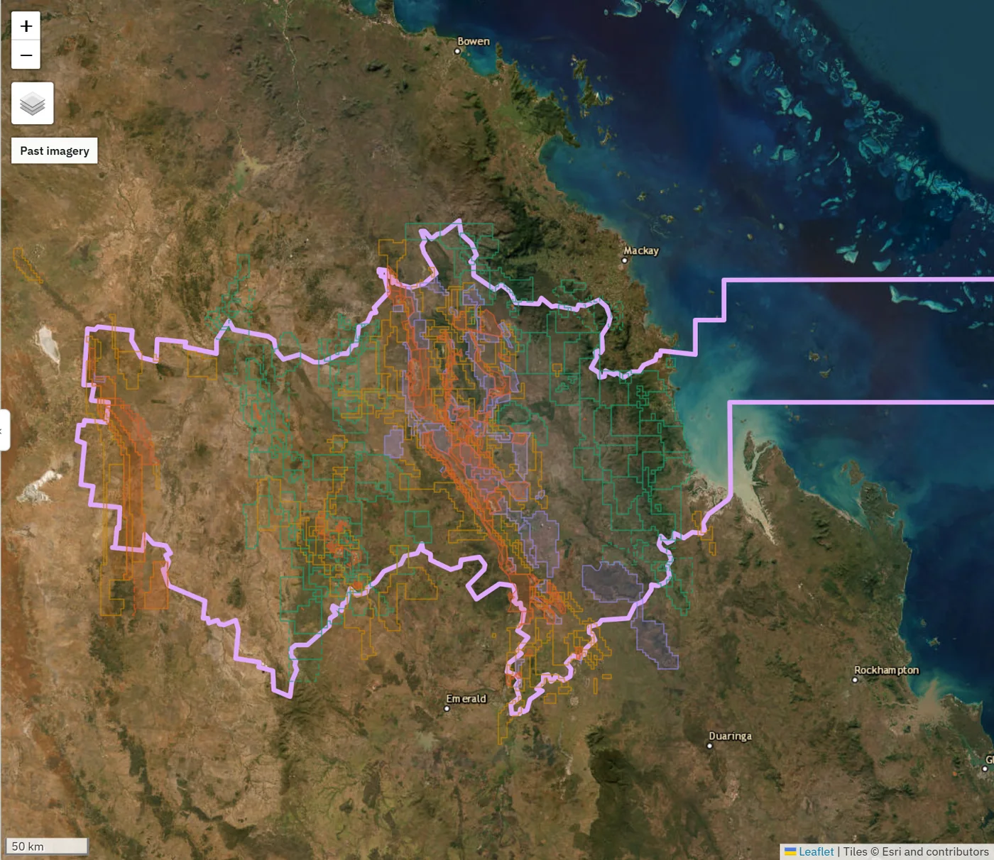
Rehabilitation liability in both states, site by site and owner by owner
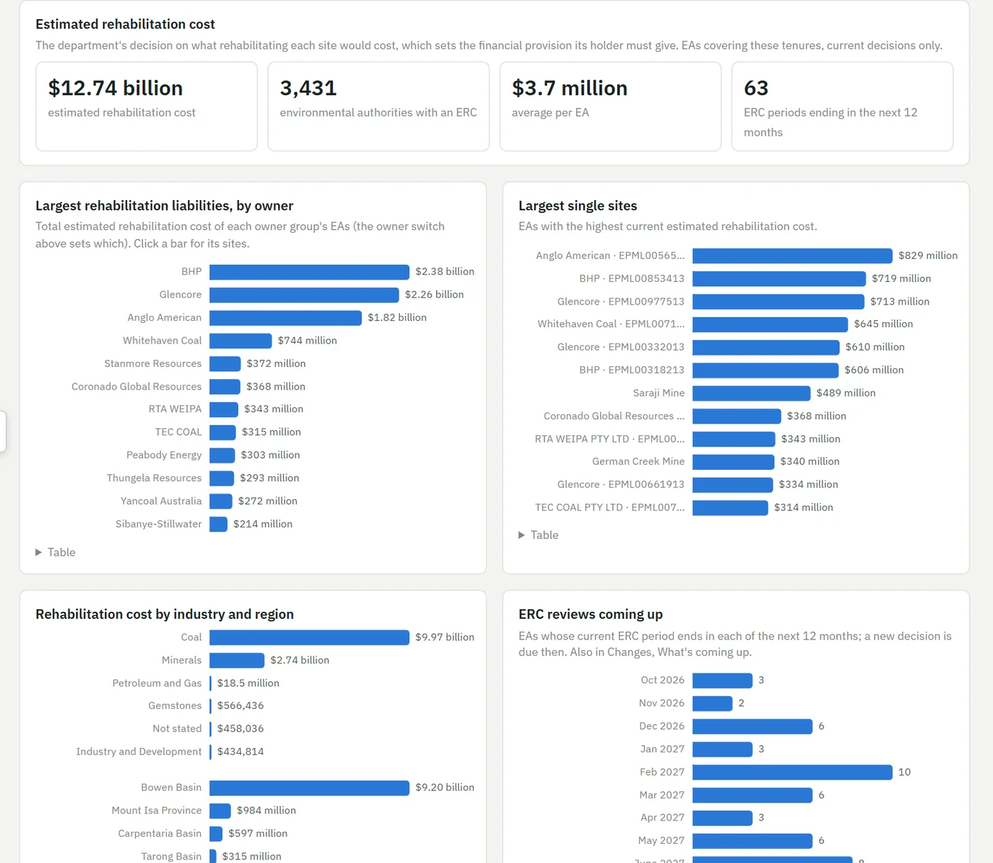
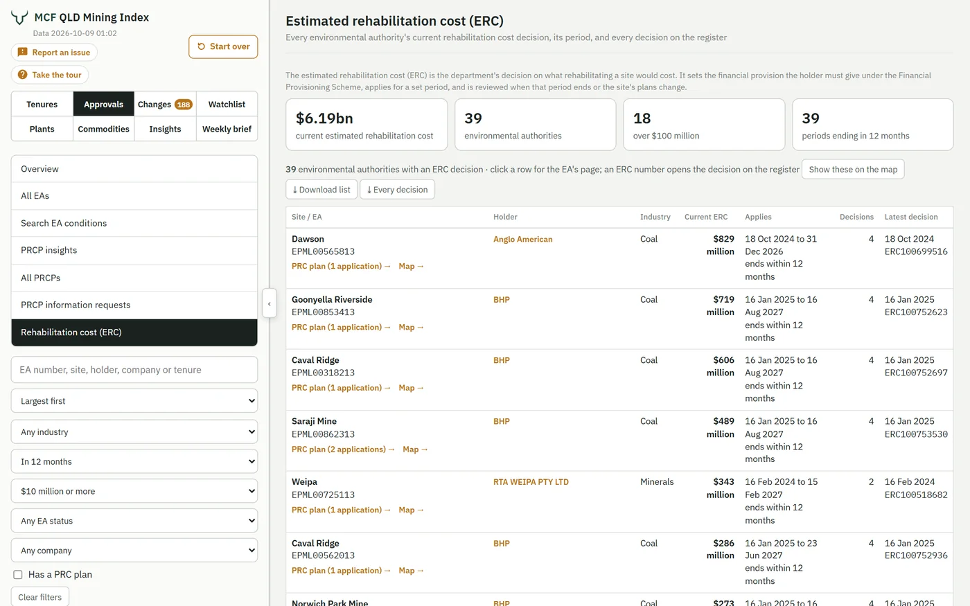
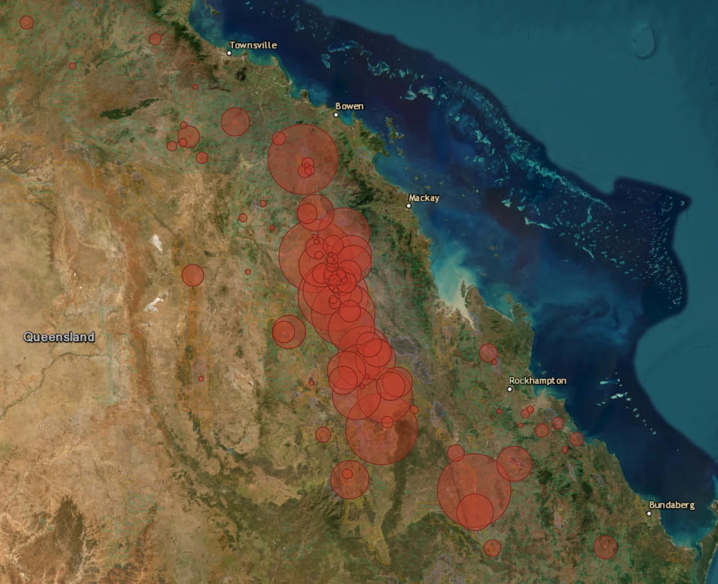
Queensland's regulator decides an estimated rehabilitation cost (ERC) for each site, which sets the financial provision the holder must give. Western Australia's Mining Rehabilitation Fund publishes each tenement's disturbed land each year, from which the rehabilitation liability estimate behind its levy is worked out. The index has both, on the map, on each tenure and totalled for each company and group.
 12345
12345Who carries the liability, and where
- The regulator's estimate for every site, totalled
- The largest liabilities by owner group: click a bar for its sites
- The largest single sites
- By industry and by region
- Reviews due in the next 12 months, when a new decision is made
 123456
Every site's ERC in one list, with the periods ending
- Totals that follow your filters
- Filter by company, amount, period ending, industry, EA status and PRC plan
- Show the list on the map, then come back with your filters still set
- Download the list, or every decision with its dates and amounts, to Excel
- Straight to the site's PRC plan, or its tenures on the map
- Each decision opens on the government register
The MRF liability estimate, on every tenement that has one
WA publishes disturbance, not bonds. The WA edition turns each year's Mining Rehabilitation Fund release into the liability estimate for each tenement, with its history back to 2014, and totals it by company and group.
- On the tenement card: the MRF estimate, disturbed and rehabilitated land, and its history
- By company: totalled across every tenement the group holds
- Where the Fund has no figure, an MCF estimate from satellite imagery, labelled as such
Mine closure plans and company provisions
Mining proposals and mine closure plans registered with the Department of Mines, Petroleum and Exploration, linked to their tenements, with the closure cost each plan states, alongside the rehabilitation provisions companies report.
- 210 closure plans with a stated cost, A$805 million in all
- Every plan version, with its date and the register document
- Company provisions beside the plan cost and the MRF estimate
Every environmental approval, searchable, with its conditions
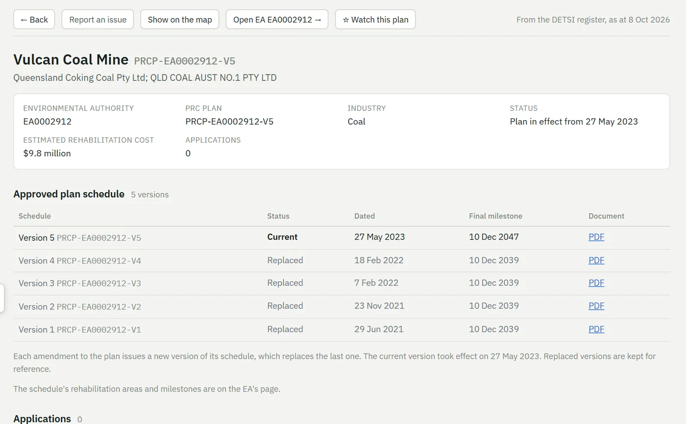
In Queensland, every mining environmental authority and its conditions, read from the permit documents, and every progressive rehabilitation and closure (PRC) plan with the regulator's information requests and the companies' replies. In Western Australia, EPA Ministerial Statements under Part IV, DWER licences and works approvals under Part V, mining proposals and closure plans, linked to their tenements, with every condition searchable. Each night the index checks the registers and records what changed.
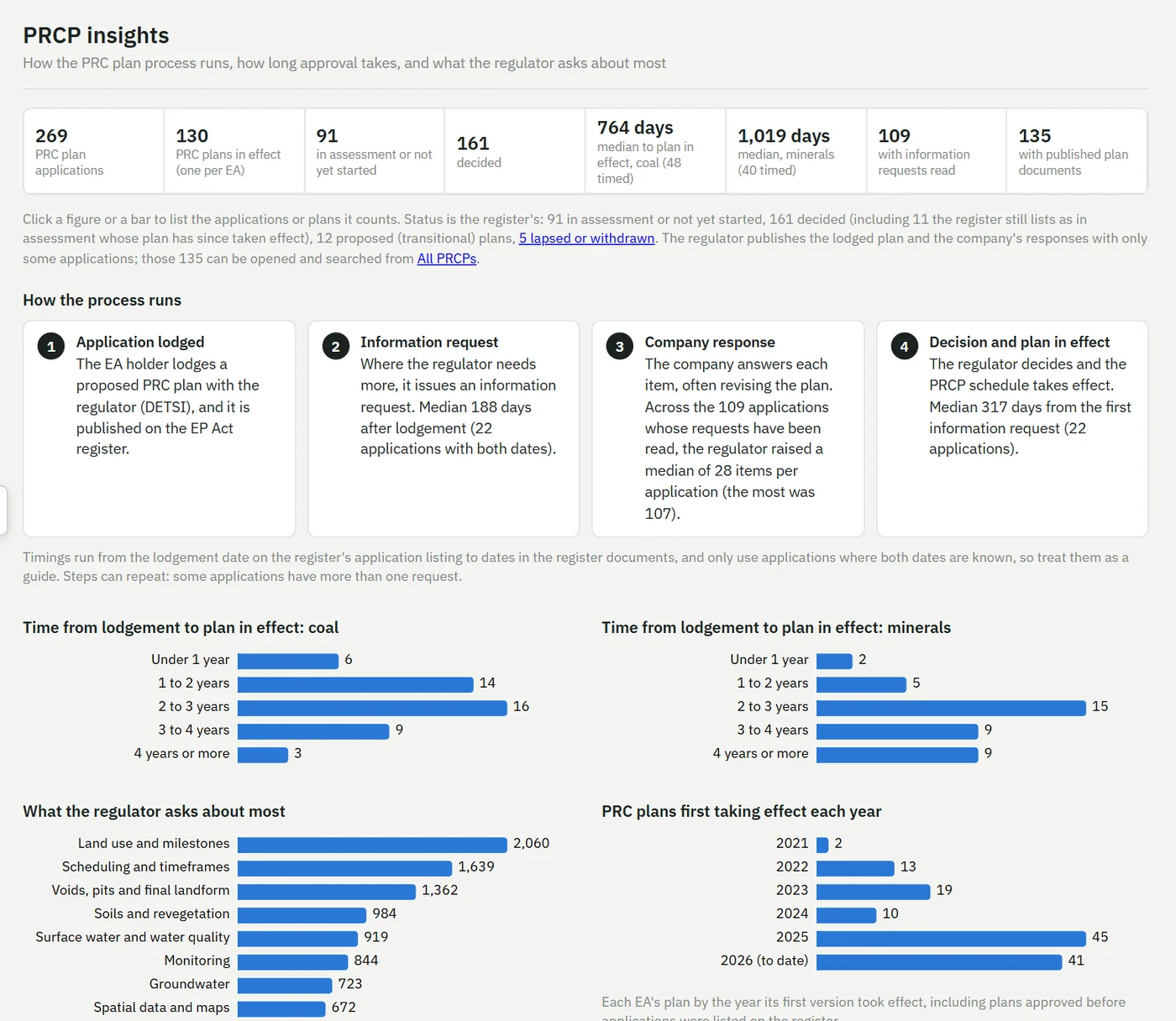
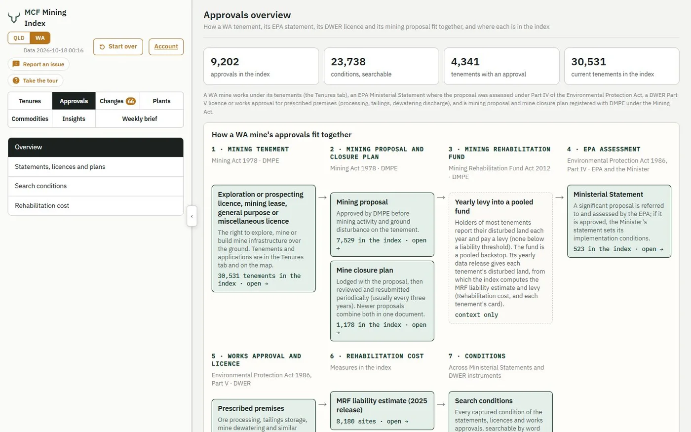
In Queensland, each PRC plan has its own page, linked both ways with its EA: its schedules, every application with its dates and documents, and what the regulator asked. Watch any EA and its changes are emailed the next morning. In WA, the DWER register and EPA statements are refreshed weekly.
Watch any area, company or tenure and get an email the morning after it changes
Draw a box on the map in either state, pick a commodity if you like, and choose the kinds of change you want: every one inside it lands in your inbox the morning after, grouped so a busy week stays readable. One watchlist covers Queensland and Western Australia.
- An area you draw, with or without a commodity focus, in Queensland, in WA or in both
- A company or group: its authorised holders, grouped into parent companies by MCF, across both states
- A tenure, a region (a mineral field in WA) or a commodity statewide
- Daily, the morning after a change, or a weekly roundup on Mondays
- New applications
- Renewals
- Transfers
- Ground released
- Expiries
- EA changes (Qld)
- PRC plans (Qld)
- Rehabilitation cost
- Exploration reports
Your tenure watchlist: 14 changes in the week to 11 Oct 2026
Text in blue is a link: click a permit number to open it in the index; EA page, new permit (PDF) and report links open the document itself.
14 changes on your watchlist this week.
Copper in an area drawn around Mount Isa (14)
| EPM 12205 | Mulga Minerals Pty Ltd | Company report released Annual report: EPM12205 Cloncurry North Annual Activity Report for Period Ending 05 September 2021 open on the GSQ Open Data Portal | all minerals except coal |
| EPM 12561 | MOUNT ISA MINES LIMITED | Company report released Annual report: EPM12561 Fountain Range Annual Activity Report for Period Ending 09 August 2021 open on the GSQ Open Data Portal | all minerals except coal |
| EPM 25867 | Mulga Minerals Pty Ltd | Renewal granted Expiry 2 May 2026 → 2 May 2031 | all minerals except coal Name: Mt Jasper |
| EPM 25913 | NOVA STRATEGIC MINERALS PTY LTD | Company report released Annual report: EPM25913 May Downs, Mount Isa Annual Activity Report for Period Ending 05 September 2021 open on the GSQ Open Data Portal | all minerals except coal Name: Boulia |
| EPM 26397 | RED FOX RESOURCES PTY LTD | Company report released Annual report: EPM26397 Butchers Bore Annual Activity Report for Period Ending 09 September 2021 open on the GSQ Open Data Portal | all minerals except coal Name: Butcher Bore |
| EPM 26413 | YAMBUNGAN PTY LTD | Company report released Annual report by RIO TINTO EXPLORATION PTY LIMITED: EPM26413 Yambungan Annual Activity Report for Period Ending 07 September 2021 open on the GSQ Open Data Portal | all minerals except coal Name: Yambungan |
| EPM 26416 | EVOLUTION MINING (CONNORS ARC) PTY LTD | Company report released Annual report by RIO TINTO EXPLORATION PTY LIMITED: EPM26416 Cubbaroo Annual Activity Report for Period Ending 07 September 2021 open on the GSQ Open Data Portal | all minerals except coal Name: Cubbaroo |
| EPM 26676 | ROSEBY COPPER (SOUTH) PTY LTD | Company report released Annual report: EPM26676 Kanata Annual Activity Report for Period Ending 09 September 2021 open on the GSQ Open Data Portal | all minerals except coal Name: Kanata |
| EPM 28318 | BLUEY BEEMAN PTY LTD | Company report released Partial relinquishment report: EPM28318 Lake Julius Partial Relinquishment Report for Period Ending 09 October 2026 open on the GSQ Open Data Portal | all minerals except coal Name: Lake Julius East |
| EPML00887913 | COPPER RESOURCES AUSTRALIA PTY LTD | EA conditions revised New version effective 29 Sep 2026: 39 changed (A2, A4, A12, A14, B4, B11, …); 16 added (A15, B16, B17, C6, C7, C9, …); 55 removed (A1, A5, A7, A8, A9, A10, …) EA page | Ancillary 07 - Chemical manufacturing; Ancillary 08 - Chemical Storage; Ancillary 14 - Electricity generation and 5 more · Minerals · covers ML90177, ML90188, ML90219 |
| EPM 18053 | Fetch Metals Pty Ltd | Area reduced 4,162 ha → 1,921 ha · relinquishment is often required at renewal | all minerals except coal |
| EPM 28318 | BLUEY BEEMAN PTY LTD | Area reduced 17,668 ha → 15,741 ha · relinquishment is often required at renewal | all minerals except coal Name: Lake Julius East |
| EPM 27128 | ISA TENEMENTS PTY LTD | Renewal lodged Current expiry 27 Jan 2027 | all minerals except coal Name: Middle Creek |
| EPM 28860 | MCG Minerals Pty Ltd | Native title category changed Expedited → Granted with Native Title Protection Conditions | all minerals except coal Name: Coppermine Creek |
Factual information from Queensland Government public registers (resource authorities and the Environmental Authority register), compared with the previous day. © State of Queensland, CC BY 4.0. Compiled from public records and may contain errors; check the official register before relying on it. Not financial product advice. Change your watchlist in the index (Watchlist tab). Choose which kinds of change you're emailed about, and daily alerts, a weekly roundup or none, on your account page. Unsubscribe from watchlist alerts with one click. Mining Capital Funds Pty Ltd, ABN 72 689 736 641, PO Box 3447, South Brisbane QLD 4101.
 123
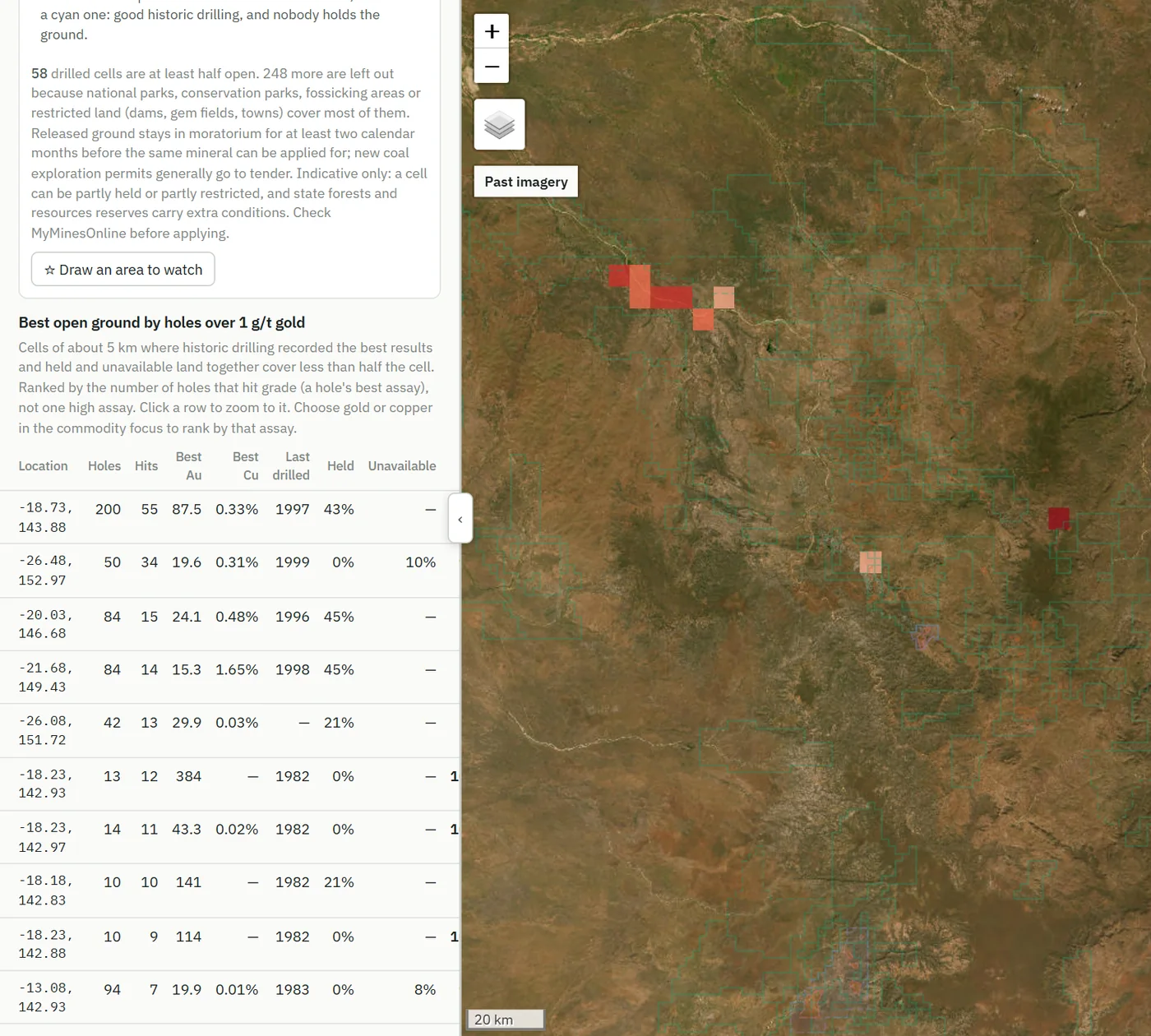
123Where old holes hit gold and nobody holds the ground
- Ranked by holes that hit grade: here, over 1 g/t gold in Queensland
- Five-kilometre cells, drilled and mostly unheld
- National parks and restricted land already taken out
- In WA, 17,152 drilled cells from the WAMEX open-file holes, 5,328 of them less than half held, plus the ground released in the last 12 months
 1234
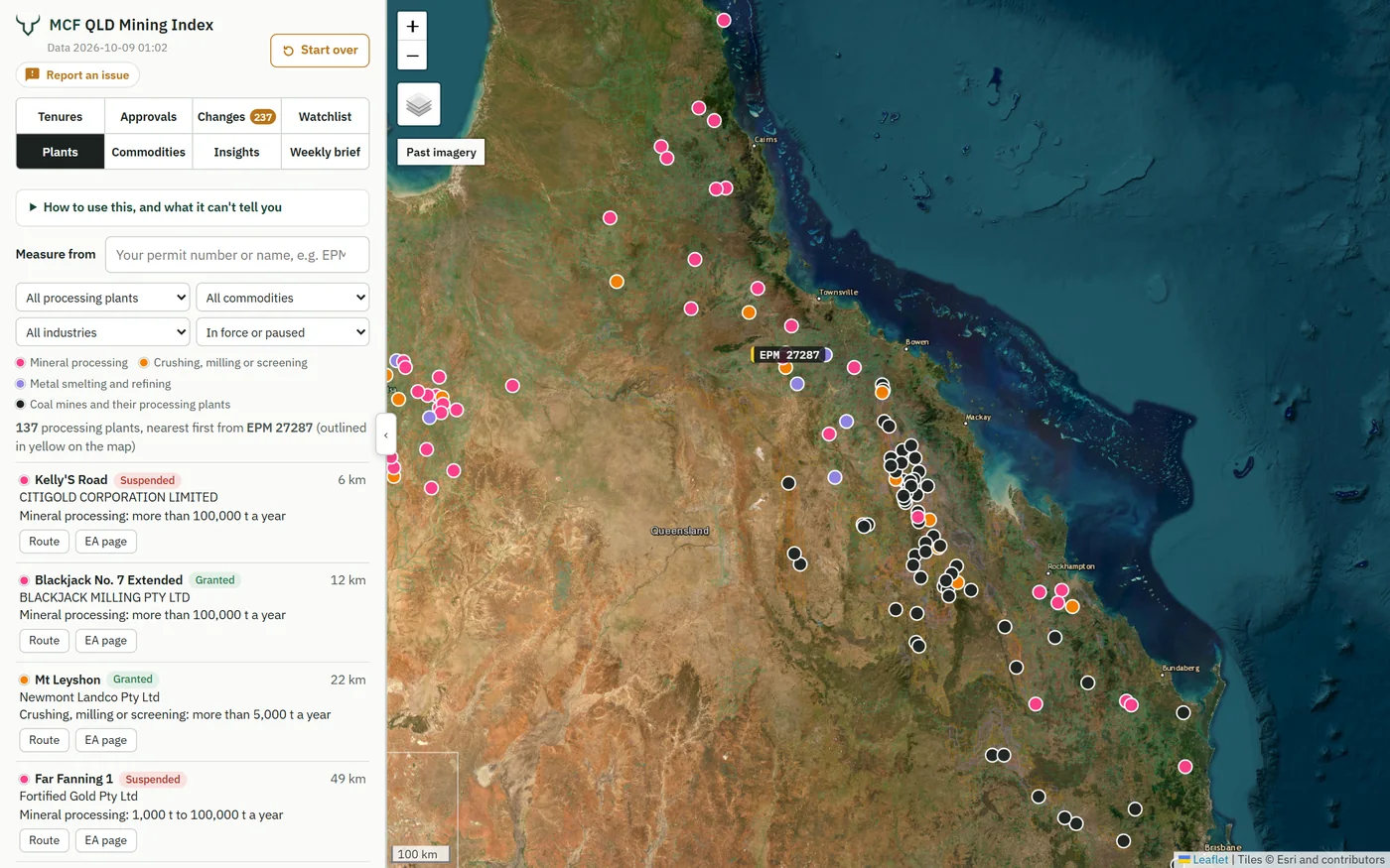
1234Every licensed processing plant on the map, nearest to your project first
- Type your permit and the list sorts by distance from it: here, a gold project at Charters Towers
- Mineral processing, crushing and screening, or smelting and refining, for minerals or coal
- The size of plant each EA is licensed for
- Open the EA's conditions and documents, or see the site on the map
- In WA, ore processing, tailings and dewatering are licensed by DWER as prescribed premises: each licence and works approval is linked to its tenements, with its conditions
Exploration reports as they're released, each logged against its tenure
Company exploration reports appear quietly on each state's portal. In Queensland, 175 were released on the Geological Survey of Queensland portal in the last 30 days, and the index logs each one against its tenure the day it's released. In Western Australia, WAMEX reports are linked to the tenements they cover, on more than 30,000 of them. Every Monday the brief names the week's moves in the states you choose.
- Springsure Creek Coal Partial Relinquishment Report for Period Ending 09 September 2026Springsure Creek Coal · EPC 1231 · Arcturus, Central Highlands Region
- Partial Relinquishment Report for Period Ending 09 August 2026Silver Star Resources · EPM 12858 · Texas, Goondiwindi Region
- Dry Creek Extension Partial Relinquishment Report for Period Ending 27 January 2026ISA Tenements · EPM 18174 · Cloncurry, Cloncurry Shire
- Comet Ridge Annual Activity Report for Period Ending 09 September 2021Coking Coal One · EPC 1230 · Togara, Central Highlands Region
- Vulcan Mine Complex Annual Activity Report for Period Ending 09 September 2021Queensland Coking Coal · EPC 1238 · Dysart, Isaac Region
- Karin Basin Annual Activity Report for Period Ending 09 September 2021Vitrinite · EPC 1240 · Lowestoff, Central Highlands Region
Queensland mining market brief, week to 14 Oct 2026
The week's headlines
- ROX 1 Pty Ltd's EPM 28672 (Mount Nolan) ended, 28,229 ha of all minerals ground.
- ML 10028 (The Highway), bismuth, copper and molybdenum at Seventy Mile, Charters Towers Region, moved from Thalanga Copper Mines Pty Ltd to Highway Copper Gold Pty Ltd.
- Copper Resources Australia Pty Ltd's environmental authority EPML00887913 was reissued. New version effective 29 Sep 2026: 39 changed (A2, A4, A12, A14, B4, B11, …); 16 added (A15, B16, B17, C6, C7, C9, …); 55 removed (A1, A5, A7, A8, A9, A10, …).
Everything in the full index
The free map shows who holds what in Queensland. The full index shows what's changing, what's coming up, what the regulator is asking and what each site would cost to rehabilitate, every night, in every edition.
One person. Or A$1,500 a year.
Up to five people, each with their own watchlist and alerts.
More people, data feeds, custom alerts.
Founding offer. The first 20 subscribers can take Professional for A$1,200 a year, kept for as long as they stay subscribed.
Free Queensland mining tools, no sign-in
Public reference pages from the Queensland data, updated daily: look up any tenure, holder or environmental authority, or browse the map.
Good to know
I already subscribe. Do I get Western Australia?
Yes. WA is included in every plan at no extra cost until 31 January 2027. Founding subscribers keep WA as part of their subscription for as long as they stay subscribed. Your sign-in, watchlist and settings are unchanged: use the state names at the top of the index to switch editions, and choose the states your emails cover on your account page.
Was this the MCF QLD Mining Index?
Yes. With a second state, the MCF QLD Mining Index is now the MCF Mining Index. Queensland is now its Queensland edition, at the same address.
Where does the data come from?
Each state's own registers. Queensland: the resource authority register, the Environmental Protection Act public register and the Geological Survey of Queensland's open data. Western Australia: the Department of Mines, Petroleum and Exploration's tenement data, MINEDEX and WAMEX, the Mining Rehabilitation Fund annual data release, and DWER and EPA records. Each edition names its sources and licences. The index checks them every night. As with any compiled data, check the official record before relying on it.
What's in the free map, and what's in the full index?
The free map shows every Queensland coal and minerals tenure with its authorised holder, status and expiry, and the number of its environmental authority, which has its own public page. The full index adds both editions, with the approvals and their conditions, the nightly change log on the map, what's coming up, watchlists and email alerts, rehabilitation cost, exploration reports and the Monday brief, company profiles, past imagery and map layers, open ground, historic drilling, processing plants and data downloads.
What is Queensland's estimated rehabilitation cost?
The regulator's decision on what it would cost to rehabilitate the land an environmental authority covers. It sets the financial provision the holder must give, and it is reviewed when each decision's period ends. The index takes every decision from the Environmental Protection Act public register and shows the one for the current period, with the earlier ones.
What is the rehabilitation liability estimate in WA?
WA's Mining Rehabilitation Fund publishes, once a year, each tenement's disturbed and rehabilitated land and the rehabilitation liability estimate behind its levy. The WA edition shows that figure for each tenement that has one, with its history from 2014, alongside mine closure plans with their stated costs and company provisions. Where the Fund has no figure, an MCF estimate from satellite imagery is shown, labelled as such.
How reliable is the drilling data?
It's each state's open-file compilation: the Geological Survey of Queensland's, and WAMEX in Western Australia. It is mostly historic, unverified company data. Treat assays as a guide to follow up, not a resource.
How do renewals, relinquishments and moratoriums work in Queensland?
Exploration permits run up to five years at a time, 15 in total. Renewal isn't automatic: the window opens six months before expiry (12 for leases, licences and claims) and closes when the permit expires. Relinquishing part of a permit is often required at renewal. When ground is released, the same mineral can't be applied for until a moratorium of at least two calendar months ends; new coal permits generally go to competitive tender. Grants follow native title and environmental steps, which is why they can take months.
Can I put it on my desktop or phone?
Yes. The index installs like an app, with its own icon, from Chrome or Edge on a computer, Safari on an iPhone or iPad, or Chrome on Android, and opens in its own window. Your account page has the steps.
Can I cancel, and does the price include GST?
Cancel any time from your account page; access runs to the end of the period you've paid for. Prices are in Australian dollars and include GST, with a tax invoice for every payment.
Who we are. The MCF Mining Index is published by Mining Capital Funds, a Brisbane-based investment business focused on Australian mining, which also publishes free coal, copper and gold statistics on its website. It's information, not financial or legal advice.
Queensland data from Queensland Government registers: resource authorities, the Environmental Protection Act public register and Geological Survey of Queensland open data, © State of Queensland, CC BY 4.0, refreshed nightly. Western Australian data © State of Western Australia: Department of Mines, Petroleum and Exploration; Mining Rehabilitation Fund annual data release; DWER and EPA (SLIP), with each source and licence named in the WA edition. Power lines: Geoscience Australia, CC BY 4.0. Satellite imagery: Digital Earth Australia GeoMAD 2024, Geoscience Australia, CC BY 4.0; screens and past imagery: Esri World Imagery and World Imagery Wayback, Esri and its contributors. Published by Mining Capital Funds Pty Ltd, ABN 72 689 736 641. Not affiliated with or endorsed by the Queensland or Western Australian Governments. Provided without warranty of accuracy or completeness; check the official register before relying on any record. Not financial or legal advice.